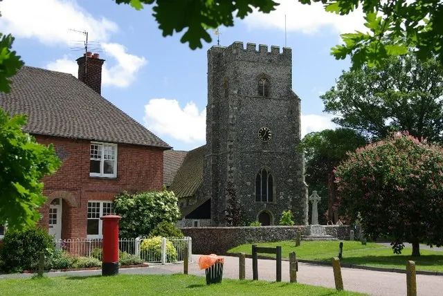
Chartham is a village and civil parish on the Great Stour, scattered along the Ashford Road on the Ashford side of Canterbury and lying on the vale of the Kent Downs Area of Outstanding Natural Beauty. it 2.3 mi (4 km) south west of Canterbury; the straight-line distance from the city centre is 3.1 km. It has a church of about 1294 beside the green, an unstaffed railway station, arable farms and orchards through the parish, and — until 2022 — a paper mill.
The reason most people come out is the journey. Chartham sits at the western end of the three-mile Great Stour Way, the riverside cycle path into Canterbury city centre, roughly where that path stops being a city walk and turns into farmland. What waits at the end is modest: a church that repays a detour if you care about medieval stonework or bells, a vineyard, two pubs, several village stores and a small venue in the village hall.
It is a working village whose economy is closely tied to Canterbury, and the Google listings are village-scale: St Mary’s Church carries 4.7 from 50 Google reviews, Chartham Vineyard 4.9 from 98, No Man’s Orchard 4.5 from 31. No visitor reviews of any of them turned up in the research behind this page.
The Church of St Mary stands next to the village green and was built in approximately 1294. Two things in it reach beyond the parish.
The first is in the chancel windows, whose stonework shows a form of tracery known as Kentish or split-cusp tracery — a style that originates here, in this building, and carries the county’s name wherever else it turns up. The second is the peal: the 14th-century tower holds six bells, five of them made by Joseph Hatch in 1605, which makes them the oldest complete set by the same bellfounder in Kent. There are brasses too, including that of Sir Robert de Setvans, who died in 1306, and the renovation of 1875 was by the Oxford University architect George Edmund Street.
The green beside it has one recorded outing of its own: for Queen Victoria’s Golden Jubilee it held a fête, with refreshments provided for paupers, seniors and children. Chartham Village Hall, the small venue in Station Road, carries 4.6 from 177 Google reviews.
Paper making has been the major occupation here for the last 625 years. The mill dates from the late eighteenth century, and the river powered the paper mills until some point before 1955. From 1938 it specialised in tracing paper, and in 2022 it closed. That is why the village reads as an industrial settlement dropped into orchard country rather than a farming hamlet that grew.
The census figures show the same shape: 776 people in the parish in 1801, across about 3 square miles (8 km2), roughly stable until the late 19th century, then 2,473 by 1881.
The other large employer has gone too. St Augustine’s Mental Hospital, formerly the East Kent Lunatic Asylum, stood at Shalmsford Street until recently; housing development began on the site in 1997, keeping the administration block, water tower and chapel and demolishing the rest. The council suggested a change of name would create a new sense of identity, and the estate is now called St Augustine’s Estate while its signs read Chartham Downs. It lies nearer Street End, Nackington and Thanington than the far end of the village, and is in many ways cut off from it.
Chartham is really several settlements. Shalmsford Street runs contiguously west and holds Chartham Primary School, where parish meetings are held. Chartham Hatch is the northern, upper part — about 200 houses surrounded by small woods and by orchards of apples and pears, with a village hall in the centre that used to be the school. The North Downs Way passes through it, and No Man’s Orchard, a nature reserve listed against the Kentish Stour Countryside Partnership, lies on that side of the parish.
Chartham Vineyard is listed at Burnt House Farm on Station Road, where a dovecote that is a Scheduled Ancient Monument as well as an architecturally notable building, for its part in sending homing birds to and from important envoys such as the Archbishop of Canterbury.
North-east, on the Great Stour Way, is Horton, a hamlet with a weir, a Grade II listed manor house and the scheduled remains of a manor chapel; land here was granted by King Æthelwulf of Wessex to Ealdorman Eadred in 844. South-west along the river stands the 16th-century, Grade II* listed Mystole House.
Two of the most-reviewed places in the parish are neither historic nor central: on the Ashford Road, Canterbury Chartham Garden Centre carries 4.1 from 437 Google reviews and Under 1 Roof Canterbury, a children’s amusement centre, 4.2 from 513.
By bike or on foot, the Great Stour Way is the point of the trip: three miles of riverside path with Chartham at the western end and the city centre at the other, on sections traffic-free and easy enough for beginners and families. Beryl’s shared e-bike scheme in the city lists that riverside route among the journeys it covers, though no bay in the village itself is established here. Cyclists carrying on west should know that National Cycle Route 18 to Royal Tunbridge Wells is signed apart from a gap between Mystole and the A28 near Godmersham.
By train, Chartham is one stop westbound from Canterbury West on the high speed line to London, though high speed services do not stop here and HS1 trains to St Pancras pass straight through; regular trains run to London Charing Cross. The station is unstaffed, carries 4.4 from 18 Google reviews, and its level crossing has recently been upgraded from a staffed crossing to an automatic barrier. Services to Canterbury are frequent daily but may thin at weekends and on bank holidays, which matters for a late train back to a village halt.
By road, the village strings along the Ashford Road, the A28 running west out of Canterbury towards Ashford; Stone Street, a road and small hamlet, runs parallel to it on the other side of the villages.
There is no verified bus. Stagecoach in East Kent runs the city’s network, but no Canterbury-to-Chartham service is established in the research behind this page, so the train and the path are the car-free options to rely on.
The village and what is around it, at walking scale.
Open any of them in Google Maps for directions and current opening.
Attractions, prices and availability in Canterbury
These come from GetYourGuide's booking widget, which sets their cookies in your browser. Consent to load it and see the attractions and prices.
Background on Chartham draws on its Wikipedia article, text there being available under CC BY-SA 4.0.