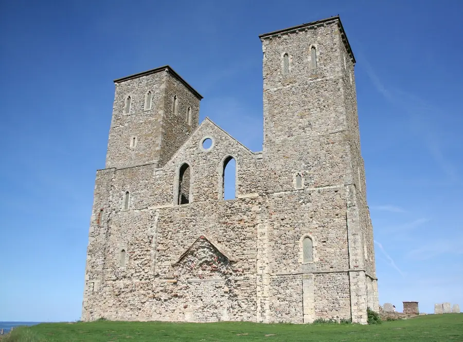
Reculver is a village and coastal resort on the north coast of Kent, in the City of Canterbury district, about 3 miles (5 km) east of Herne Bay. It amounts to one silhouette: the twin west towers of a demolished medieval church, on a low clifftop inside the walls of a Roman fort, sea in front and flat land behind.
Almost nothing else of the old settlement is left. The village was largely abandoned around the end of the eighteenth century, and most of St Mary’s Church was demolished in 1809. The towers survive for a practical reason rather than a sentimental one: Trinity House kept them as a navigational aid, buying what remained for £100 in 1810 and building the first groynes to protect the cliff beneath. They still do the job: the towers mark the boundary between the Thames and Dover maritime rescue coordination centres.
From Canterbury the straight-line distance is 13.8 km.
The two layers are not equally visible. The Romans built a small fort here at the conquest in 43 AD, and from late in the second century a full castrum, Regulbium, one of the chain of Saxon Shore forts, abandoned in the 370s. Its north wall and most of the west wall have gone into the sea, and what survives lost its facing stone long ago. A visitor in April 2026 put the result fairly: “The towers share the site with the remains of a Roman fort, though little of this can be seen.” One in December 2025 was blunter: the fort is “basically now just a field”.
The church is the layer that reads. A monastery dedicated to St Mary was founded inside the fort in 669, on land granted by King Ecgberht of Kent, and built almost entirely from demolished Roman structures; King Eadberht II of Kent was buried in it in the 760s. The towers went up in a late twelfth-century remodelling. Missing walls are now marked out in concrete edged with flint, so the plan reads at foot level, and fragments of the church’s stone cross and two columns from its Anglo-Saxon chancel arch are in Canterbury Cathedral.
Reculver sat at the north-western end of the Wantsum Channel, the sea lane separating the Isle of Thanet from the Kent mainland. That position made the place: a weekly Thursday market granted in 1220, membership of the Cinque Port of Sandwich last recorded in 1377. Then the channel silted up, closing to trade by about 1460, and the sea took the rest from the other side.
The fort is thought to have stood about 1 mile (1.6 km) from the sea; the cliffs erode at roughly 3.3 feet (1 m) a year. By March 1809 the cliff edge was 12 feet (4 m) from the church, and the residents had already moved inland to Hillborough, about 1.25 miles (2 km) south-west. The plan today is deliberately split: the fort and church are defended, other stretches left to erode.
One of those is Reculver Country Park, a cliff-top strip running about 1.5 miles (2 km) west from the fort to Bishopstone Glen inside a Site of Special Scientific Interest, whose soft cliffs hold the largest colony of sand martins in Kent and whose meadows are among the last cliff-top wildflower meadows in the county.
The coastline east of the village was used during the Second World War to test prototypes of Barnes Wallis’s bouncing bomb — chosen for its seclusion, for the church towers as a landmark to aim on, and for shallow water that made the prototypes easy to recover. The inert versions trialled here led to the operational bomb, Upkeep, used by 617 Squadron against the Ruhr dams on the night of 16–17 May 1943. Part of one surfaced during beach maintenance work as recently as 2017.
Reviewers of Reculver Towers and Roman Fort, rated 4.6 from 2,515 Google reviews, divide on whether there is enough here. A visitor in July 2026 made both cases: “At the end of the day, there isnt much to see, old ruined towers, small pebble beach and a big expanse of sea,” and then “Reculver is maybe one of the most peaceful places ive been”. One in June 2026 pushed back: “did you miss the huge ruins?”
Three practical things recur. The approach is a hill: a visitor in December 2025 warned that “The path is accessible, but the site itself is not, so those with reduced mobility or wheelchair users may struggle.” The site is exposed — one in May 2026 found that “It can get quite windy as it’s very open”. And the car park draws steady complaint about its charges, from “the parking is overpriced” in March 2026 to a visitor in April 2026 who allowed that it “was a bit expensive for what the area has, but we ended up enjoying the nice little walk to the Tower and along the beach.”
Going inside the north tower is not a given: a visitor in April 2026 advised that “the north tower is only open on select days, so check dates in advance if you’d like to look inside”. Facilities sit at the bottom of the path rather than at the ruins — a visitor in September 2025 listed “café (HatsHats), pub (The King Ethelbert), playground for younger kids, public toilets (dated but everything worked)”. Beyond those, modern Reculver is static caravan parks.
There is a bus. Services calling at a stop next to the King Ethelbert Inn connect Reculver with Herne Bay, Canterbury, Birchington and Margate. The pack gives no route numbers or frequencies, so check the timetable before relying on it for the return.
Reculver Lane, unclassified, ends here: the village about 2 miles (3.2 km) by road from the nearest major junction of the A299, the Thanet Way.
There is no station, and there never was one: a passenger station was proposed in 1864 and not built, and an 1884 branch line that would have linked Canterbury and Herne Bay through a junction here was rejected. The nearest are Herne Bay, about 3.8 miles (6.1 km) west, and Birchington-on-Sea, about 4.5 miles (7.2 km) east.
The last approach is the good one. Walkers and cyclists reach the towers along the coast: a visitor in February 2026 simply “Walked from Herne Bay to Reculver Towers”, and one in September 2025 called the site a place to stop “if you’re walking or cycling along the Saxon Shore Way”.
The village and what is around it, at walking scale.
Open any of them in Google Maps for directions and current opening.
Attractions, prices and availability in Canterbury
These come from GetYourGuide's booking widget, which sets their cookies in your browser. Consent to load it and see the attractions and prices.
Background on Reculver draws on its Wikipedia article, text there being available under CC BY-SA 4.0.