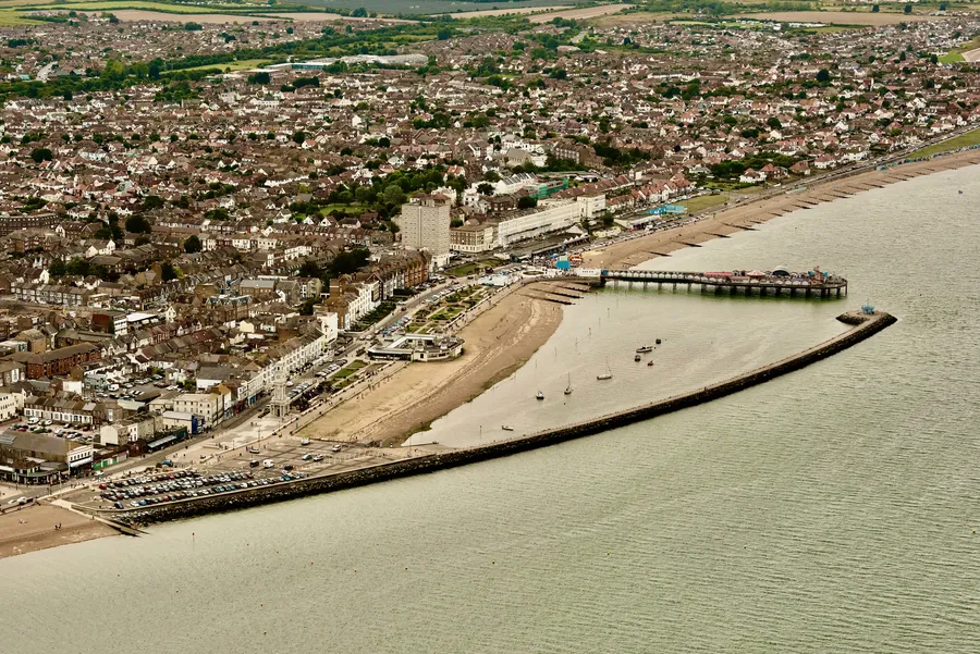
Herne Bay is a seaside town on the north coast of Kent, and the thing it is best known for is no longer attached to it. Out in the water, beyond the end of the present pier, stands the isolated head of the old one: from the late Victorian period until 1978 this was the second-longest pier in the United Kingdom. What is left ashore is a stub of deck lined with converted beach huts, an arcade behind it, and a clock tower of 1837 believed to be the first freestanding, purpose-built clock tower in the world. That is the case for coming out from Canterbury: boom, collapse and patching-up, all along one promenade.
The town is 10.7 km from Canterbury in a straight line; it as 6 miles (10 km) north of the city. It sits in the City of Canterbury local government district but remains a separate town, with countryside between the two, and had 38,563 people at the 2011 census.
The surviving pier carries huts selling food, drink and craft goods, with fairground rides and a carousel at the end, and is heavily used for crabbing and fishing. It rates 4.4 from 4,248 Google reviews, high for something so reduced. A visitor in July 2024 wrote, “This 19th century pier was one considerably longer, what used to be the end of the pier can still be seen out to sea.”
Two warnings recur. Off-season the stalls thin out — in June 2026 a visitor reported that “All shops on the pier itself only open weekend, holidays and bank holidays” — and in May 2026 another advised that “you can use the toilets on the pier, but they are in poor condition and have a very unpleasant odor”. Behind the entrance is Cain’s Amusements, an arcade rating 4.2 from 928 Google reviews.
The first pier was timber, built in the 1830s by London investors who had spotted the town’s potential as a resort. It was dismantled in 1871 after its owners went into liquidation and sea worms damaged the wood. A shorter iron replacement of 100 metres (328 ft) went up in 1873, but it was too short for steamboats to berth at and did not pay.
So in 1896 work began on a third pier: iron, with an electric tram, and at 3,600 feet (1,097 m) the second longest in the country behind Southend-on-Sea. A pavilion went up at the landward end in 1910. In the Second World War the army cut two gaps between that end and the seaward terminal as a counter-invasion measure, bridged for pedestrians afterwards. Steamboat services ended in 1963; fire destroyed the pavilion in 1970, and the sports centre replacing it was opened in 1976 by the former Prime Minister Edward Heath.
In 1978 a storm tore out the centre section and left the pier end stranded offshore. Cost has kept it from being rebuilt, though residents and businesses have campaigned for it — a point a visitor still made in April 2019: “Shame the council do not reinstate the full length of the pier.” The sports centre was demolished in 2012, leaving a bare platform.
The Clock Tower of 1837 stands on Central Parade, 75 feet (23 m) high, paid for by Ann Thwaytes, a wealthy widow from London. It rates 4.5 from 748 Google reviews. It is not immaculate: a visitor in January 2025 called it “a historical landmark though it has seen better days”, and one in July 2026 noted that it “Doesn’t ding on the hour most of the time.. It’s usually early or late”.
The rest of the stretch is restored Victorian gardens and the Central Bandstand of 1924. Neptune’s Arm, the 1990s breakwater built when the older sea defences were judged inadequate, has made a small harbour for leisure boats and a departure point for yacht trips to a seal-watching site in the Thames Estuary.
The beach is 2 miles (3 km) of shingle with a European Blue Flag and Seaside Award, rated 4.5 from 2,395 Google reviews. A visitor in December 2022 noted that “Some parts of the beach shelve quite steeply in places, others nice and flat - easy to see when the tide is out.” On the horizon sit a Second World War sea fort off the Herne Bay and Whitstable coast and a wind farm of thirty turbines, built in 2005 five miles (8 km) offshore.
Behind the front, the town has declined as a holiday destination over decades, and repeated flooding of the Plenty Brook, which runs under the town centre, held back redevelopment. A visitor in March 2026 was harsh about it: “Visited for the first time and it was awful. Maybe I was just unlucky that day. Alcoholics, weed, fighting.” That is one bad day among many good ones, but it is in the record.
By road, the A299 Thanet Way runs between Ramsgate and Faversham via Herne Bay and Whitstable, joining the M2 at Faversham. Parking is the usual seafront lottery: a visitor in November 2022 found that “Car parks fill up quickly but usually find a spot without too much trouble”, while one in May 2024 called it “Extortionate parking for little.”
The bus is the link the pack verifies. Stagecoach South East runs the Triangle, 6 and 36 services to Whitstable and to Canterbury, where many Herne Bay residents work and shop. Buses leave Canterbury from the bus station at the end of the high street, regularly through the day and less often in the evenings. Service 7, which once linked the two towns, was shortened significantly in June 2022.
Herne Bay has its own station, on the Chatham Main Line between Ramsgate and London Victoria and served by Southeastern high-speed trains to St Pancras. But the stations the pack names on that line are coastal ones — Whitstable, Faversham, Margate, Broadstairs — not Canterbury, and it establishes no direct rail service from the city. Treat the bus as the car-free route. The front is close in once you arrive: a visitor in August 2022 put the beach at “10 min walk from rail station”. No cycle route between the two towns appears in the pack either.
The village and what is around it, at walking scale.
Open any of them in Google Maps for directions and current opening.
Attractions, prices and availability in Canterbury
These come from GetYourGuide's booking widget, which sets their cookies in your browser. Consent to load it and see the attractions and prices.
Background on Herne Bay draws on its Wikipedia article, text there being available under CC BY-SA 4.0.