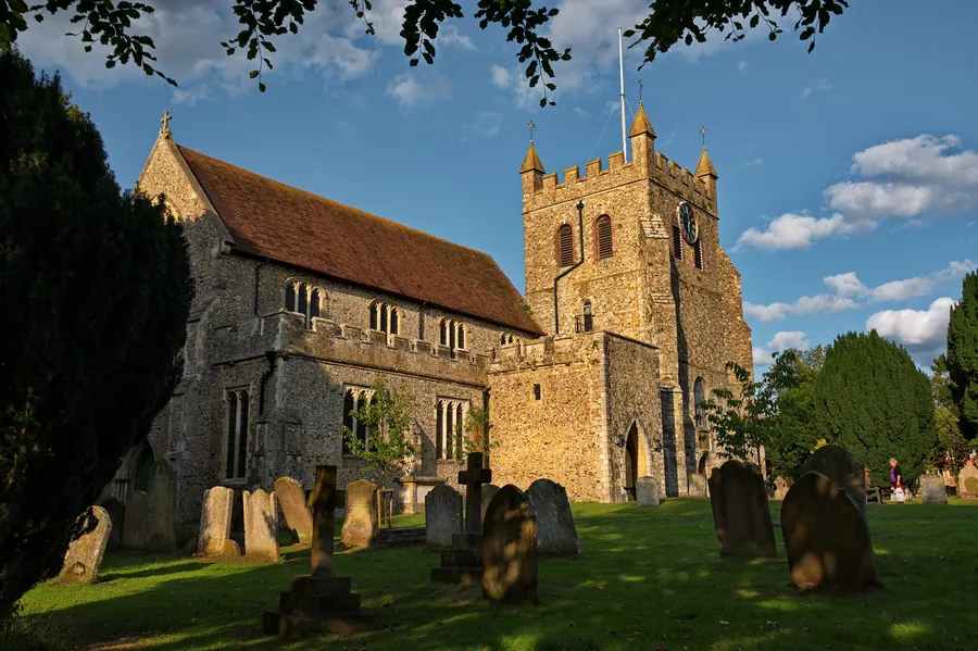
Wye is a village on the Great Stour in the Ashford district of Kent, where the river cuts through the North Downs. it 12 miles (19 km) from Canterbury and 5 miles (8.0 km) from Ashford; straight-line from Canterbury it is 14.6 km. It is the main settlement in the parish of Wye with Hinxhill.
The reason to come out from Canterbury is the scarp above the village. A hill figure, the Wye Crown, was cut into the chalk by Wye College students in 1902 to mark the coronation of Edward VII, and the downland behind it breaks into dry valleys, the best known being the Devil’s Kneading Trough. The same college bred hop varieties, Wye Challenger among them, named for the village. In 2013, Sunday Times readers voted Wye the third best place to live in the UK.
Wye Crown forms part of the Wye and Crundale Downs Site of Special Scientific Interest and, listed as the Wye Memorial Crown, draws 4.7 from 127 Google reviews. The Wye Downs above it — chalk downland and woodland in the same SSSI — hold the Kneading Trough and other coombes formed by periglacial action, and carry 4.8 from 66 Google reviews; the Kneading Trough itself has 4.8 from 41.
Reviewers describe a long view outward and a steep drop underfoot. A visitor in February 2023 wrote of “a viewpoint to grasp the view of Ashford city from the hill” and of “The coombe, having a steep slope and a warning sign of ‘unexploded ordnance’”, adding that “The track gets mucky at times, so mud boots or shoes with good grip are advised.” A visitor in July 2023 was blunter about who the ground suits: “not suitable for people in wheelchair as very steep in places and uneven ground. Signage poor.”
A visitor in January 2018 described the circuit from above: “We starter at the top of the downs walked down into Wye for a lovely pub lunch at the tickled trout, then back up onto the crown and to the car.”
The Wye Nature Reserve Car Park on the downs holds 4.6 from 142 Google reviews. It is small: a visitor in March 2025 counted “Room for 20 cars to park or thereabouts”, and one in December 2020 noted “There are two car parks which serve the Wye NNR.”
The arrangements have also changed, and the reviews contradict each other. Older ones describe paying nothing, or dropping in a voluntary donation towards upkeep; a visitor in April 2025 reported the opposite — “Now you also have to pay” — with a catch: “Pay only by mobile phone so if you don’t have a mobile you can’t park.” Read the signs on arrival. There are no bins — a visitor in July 2022 wrote, “There is no litter bin, so take your trash with you.”
Wye College was founded in 1447 as a chantry by Cardinal Kempe. In 1894 the buildings reopened as the South Eastern Agricultural College, incorporated as Wye College in 1948; it merged with Imperial College in 2000 and the campus closed progressively between 2005 and 2009. In 2005 Imperial promoted a scheme to turn it into a renewable fuel research centre and build 4,000 houses in the Kent Downs. Ashford Borough Council withdrew support in 2006 and the plans were abandoned.
The grade I listed Church of Saint Gregory and Saint Martin is far smaller than it once was: its steeple tower collapsed on 22 March 1686, taking most of the chancel, almost all the transepts and part of the nave; the rebuilding of 1700 to 1711 came out at barely half the size of the old church. The street plan is much as Hasted found it in 1798, when he called Wye “a neat well-built town, consisting of two parallel and two cross streets, the whole unpaved”. A farmers’ market is held by The Green on the first and third Saturday of every month, with typically 15 vendors.
The Tickled Trout sits by the river with a garden running down to it, and holds 4.4 from 1,770 Google reviews. The setting is not in dispute; the service divides recent reviewers. A visitor in July 2026 wrote that “The service was the slowest I’ve ever had, slow drinks, 45 minute our mains then slow to pay the bill”. Booking helps: a visitor in May 2026 arrived without one and found it “fully booked for any group above 2 on bank holiday monday”.
The Kings Head on Church Street has 4.5 from 437 Google reviews, with rooms as well as a bar, and reviewers in 2023 describe a newly refurbished pub. The kitchen draws steady praise, but not from everyone: a visitor in July 2023 found “no beers on tap nor in bottles only 1 lager, service took hours and was patchy”. A visitor in June 2018 noted the practical catch: “Only on street parking.”
By road, the A28 runs west from Canterbury towards Ashford and passes Wye on the far bank of the Stour; an 18th-century turnpike bypassed the village on the west bank, as the A28 still does. In the village, a visitor in June 2024 recommended “parking your car in the car park at the train station (over the tracks)”.
Wye has a railway station, built for the South Eastern Railway’s Ashford to Margate line and opened on 1 December 1846; until 2022 its level crossing gates were manually operated, closing the road for 10 to 12 minutes at a time. The research behind this page does not establish the current service pattern between Canterbury and Wye, so check timetables before relying on the train. A visitor in September 2022 wrote that the reserve above “is within walking distance if you come from Wye station, but is best to come by car”.
By bike, Wye is the start and finish of the Cantii Way, a 145-mile (233 km) circular route on cycle paths, bridleways and quiet roads inaugurated by Cycling UK in 2022; it links there with National Cycle Route 18 and passes through Canterbury on its circuit. A visitor to the Kings Head in April 2018 wrote that they “always stop by when we cycle from Canterbury”.
On foot, Wye stands on the southern route of the North Downs Way, where the trail crosses the Stour Valley Walk and follows the line of the Pilgrims Way.
The village and what is around it, at walking scale.
Open any of them in Google Maps for directions and current opening.
Attractions, prices and availability in Canterbury
These come from GetYourGuide's booking widget, which sets their cookies in your browser. Consent to load it and see the attractions and prices.
Background on Wye draws on its Wikipedia article, text there being available under CC BY-SA 4.0.